Ground conditions shift dramatically between Southend’s cliff-top conservation areas and the reclaimed estuarine flatlands along the seafront. At Southchurch, London Clay sits near surface, offering reasonable bearing capacity for embedded retaining walls. A mile south toward the pier, the stratigraphy changes completely: 5 to 8 metres of soft Holocene alluvium overlying Thames Gravel, with groundwater at 1.5 metres below ground level. This contrast means a retaining wall design that works in the northern residential grid can fail at the seafront if the designer ignores pore-water pressure build-up behind the stem. We have designed retaining walls in Southend-on-Sea for over a decade, from gravity block walls in Leigh-on-Sea back gardens to cantilever reinforced concrete walls supporting the A13 embankment. Every design starts with a ground model that maps the exact transition between the London Clay outcrop and the tidal flat deposits, because the wall type, drainage specification, and slope stability assessment all hinge on that boundary.
In Southend-on-Sea, the difference between a wall that stands and one that tilts is 1.5 metres of groundwater—and whether the designer accounted for it.
Local context
The Thames Estuary climate imposes a corrosion regime on retaining walls that inland designers rarely encounter. Southend-on-Sea receives 530 mm of rainfall annually, but the real risk is airborne chloride from sea spray, which accelerates reinforcement corrosion in concrete cantilever walls within 500 metres of the mean high-water mark. Our retaining wall designs for Southend-on-Sea specify a minimum 50 mm concrete cover in XS3 exposure class (tidal and splash zones) per BS 8500-1, and we require chloride migration testing on the proposed mix. The second risk is short-term: a rapid drawdown of the Thames tide can drop the external water level by 4 metres in under three hours, leaving the wall backfill saturated while the passive resistance in front drops with the water. We model this transient condition using SEEP/W finite-element seepage analysis, and the resulting hydraulic gradient often governs the required embedment depth rather than the long-term earth pressure case. In the soft alluvium zone, deep excavation monitoring with inclinometers and piezometers during construction is standard practice.
Common questions
Do I need planning permission for a retaining wall in Southend-on-Sea?
Under the Town and Country Planning Act, a retaining wall over 1 metre high adjacent to a highway, or over 2 metres elsewhere, generally requires planning permission. Southend-on-Sea Borough Council’s planning department also checks impact on flood zones 2 and 3, which cover much of the seafront and the lower reaches of Prittle Brook. We prepare the geotechnical design statement and cross-section drawings that the council’s building control team requires.
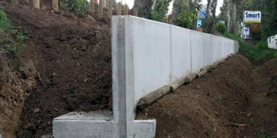
Which type of retaining wall suits the soft ground near the seafront?
In the soft alluvium zone south of Southchurch Road, embedded walls such as sheet piles or secant piles are almost always required because the undrained shear strength of the alluvium (typically 15–25 kPa) cannot support a gravity wall's bearing pressure. Sheet piles driven into the underlying Thames Gravel provide both toe fixity and a groundwater cut-off, which is critical given the tidal influence on pore pressures.
How does Eurocode 7 apply to retaining wall design in the UK?
Eurocode 7 (BS EN 1997-1) applies to all geotechnical structures in the UK, including retaining walls. We use Design Approach 1, which requires two combinations of partial factors: Combination 1 (A1+M1+R1) governs structural design, while Combination 2 (A2+M2+R1) governs geotechnical sizing. For Southend-on-Sea’s soft alluvium, Combination 2 usually controls the wall embedment depth because the partial factor on undrained shear strength is 1.4.
What ground investigation is needed before designing a retaining wall?
A ground investigation for retaining wall design in Southend-on-Sea must include at least one borehole per 30 linear metres of wall, with SPTs every 1.5 metres, undrained triaxial tests on the alluvium, and multistage triaxial tests on the London Clay. Piezometer installations are mandatory within 500 metres of the estuary to establish the tidal lag and design groundwater profile. We also run laboratory particle size distribution to confirm the Thames Gravel’s drainage characteristics for the embedment zone.