← Home · Geophysics

MASW / VS30 Shear Wave Velocity Testing in Southend-on-Sea

Together, we solve the challenges of tomorrow.

SEE MORE →

Southend-on-Sea expanded rapidly as a Victorian seaside resort and later as a commuter hub, yet much of its development sits atop soft alluvial deposits from the Thames Estuary. The pier—the longest pleasure pier in the world at 2.16 km—is a constant reminder that foundations here deal with saturated silts and peats rather than rock. A MASW survey gives the design team shear wave velocity (Vs) profiles and a reliable VS30 value without disturbing the ground, something that matters when you are working within metres of tidal mudflats. For deeper stratigraphic control we often pair the surface wave data with spt drilling to calibrate Vs against known penetration resistance in the London Clay basement.

A VS30 shift from 180 to 210 m/s changes the site class from D to C under BS EN 1998-1, potentially cutting seismic base shear by 30%.
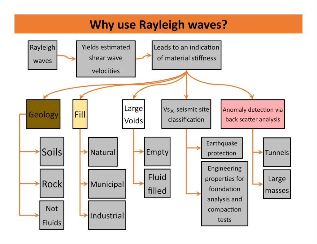
Process overview

The contrast between the seafront zone and the inland districts north of the A127 is stark. Along the seafront, loose sands and soft silty clays produce Vs values below 180 m/s in the upper 10 m, while the London Clay outcrops further inland push Vs above 300 m/s much shallower. The MASW method uses an active-source linear array and multichannel recording to extract fundamental-mode Rayleigh wave dispersion, which is then inverted to a 1D Vs profile. On compact sites where access is tight, we supplement the array with cpt testing to confirm the stratigraphy at a point. The output feeds directly into Eurocode 8 site classification: the VS30 value determines whether the ground falls into class C, D, or E—a decision that alters the entire seismic design spectrum. When the top 30 m includes interbedded clays and peats, the inversion must handle low-velocity layers carefully; a blind interpretation can misclassify a site by an entire class. We therefore run the dispersion picking through multiple algorithms and validate the model against any available borehole log or resistivity sounding data.
MASW / VS30 Shear Wave Velocity Testing in Southend-on-Sea
Technical reference image — Southend-on-Sea

Local context

Southend’s estuarine environment brings a water table that sits within 1–2 m of the surface for much of the year, and a tidal range that exceeds 5 m on spring tides. That sustained saturation keeps near-surface shear wave velocities low and amplifies ground motion during a seismic event—even a moderate one originating in the Dover Strait. The Environment Agency’s flood maps classify large parts of the borough within Flood Zone 3, which means any development requiring a site-specific flood risk assessment benefits from a MASW dataset that is already georeferenced and defensible. On reclaimed land east of the pier, the fill thickness is variable and often contains brick rubble and organic lenses; an MASW line that crosses from natural ground onto the fill will show a sharp velocity drop, flagging the transition zone for the structural engineer before excavations begin.

Need a geotechnical assessment?

Reply within 24h.

Email: contact@geotechnical-engineering1.com

Technical parameters


ParameterTypical value
Test standardBS EN ISO 22476-3, BS 5930:2015
Source typeSledgehammer on plate / weight drop
Array length23–69 m (24–48 geophones)
Geophone frequency4.5 Hz vertical-component
Investigation depthTypically 15–30 m below ground level
Output parameterVS30, Vs profile, site class per BS EN 1998-1
Data processingDispersion picking + 1D inversion (multiple modes)

Additional services

01

VS30 Site Classification

Single-line MASW survey with 1D Vs profile and formal site class determination per BS EN 1998-1 Table 3.1. Includes the VS30 calculation and a signed factual report ready for building control submission.

02

2D Shear Wave Cross-Section

Multiple parallel arrays or a rolling line to map lateral velocity variations across a site. Used where fill thickness changes abruptly, or to locate buried channels before piling design.

03

Combined Geophysical Package

MASW plus electrical resistivity tomography or seismic refraction on the same grid. Ideal for brownfield sites where buried obstructions and variable fill must be characterised alongside Vs.

Reference standards

BS EN 1998-1:2004 (Eurocode 8 – Seismic design), BS EN ISO 22476-3:2005 (MASW field procedure), BS 5930:2015+A1:2020 (Code of practice for ground investigations)

Common questions

What does a MASW survey in Southend typically cost?

For a single-line MASW survey with VS30 classification and a factual report, budgets in Southend-on-Sea generally fall between £1,360 and £2,290. The final figure depends on array length, site access conditions, and whether supplementary processing such as multi-mode inversion is required.

How does MASW compare with a downhole seismic test for getting VS30?

MASW is non-invasive and measures Vs averaged horizontally along the array, which can be more representative than a single borehole measurement. Downhole testing gives higher vertical resolution at one location but requires a cased borehole. In Southend’s soft alluvium we often run MASW first and use downhole data only where the client needs a point-specific Vs log for numerical modelling.

Can you run MASW inside a building or on a paved car park?

Active-source MASW works best on unpaved ground because the geophones need firm coupling with the soil. On asphalt or concrete we can use base plates and drilling to achieve coupling, but the high-frequency content may be attenuated. For indoor surveys we typically recommend a passive-source array or a combined active-passive approach, which we can scope after a site walkover in Southend.

Location and service area

We serve projects across Southend-on-Sea and its metropolitan area.

View larger map